Photos in White Mountains National Forest
Photos of Conway And North Conway towns
PHOTOS OF VISIT TO MOUNT WASHINGTON
( Rockpile , a path for trekkers )
WINTER PHOTOS OF LIFE AT MOUNT WASHINGTON
A VISIT TO MOUNT WASHINGTON IN NEW HAMPSHIRE
Mount Washington, located in the White Mountains range is about 55 miles from Lake Ossipee . A straight nonstop car drive of about 99 minutes. The White Mountains are a mountain range in the New Hampshire and Maine State. These rugged mountains of New England have several alpine tundra peaks amongst which Mountain Washington happens to be the highest and coldest.
Planned and organised by Sandeep, we paid a visit to Mount Washington on 30th September 2024 . Starting from our Lake Ossipee accommodation, we halted at the White Mountains National Forest Park to see the water stream moving down through forest over boulders. . The place is located in the Kancamagus area known for the finest Fall foliage in the US. The Kancamagus Highway in White Mountains stretches over an area of about 35 miles from Lincoln to conway .One needs to buy a ticket for 5 dollars to enter this highway.
The moutain range including the Mount Washington is known as White Mountains .
Established after public outcry over uncontrolled logging and fires, the the White Mountains Forest has grown to almost 800,000 acres in New Hampshire and Western Maine that now supports upwards of 6 million visitors annually.
Mount Washington Valley region, including the towns and villages of Conway, North Conway, Intervale, Glen, Jackson, Bartlett, Hart's Location, Albany, Eaton, Effingham, Freedom, Madison, Tamworth, and Ossipee.
While nearly the whole mountain is in the White Mountain National Forest, an area of 60.3 acres (24.4 ha) surrounding and including the summit is designated as Mount Washington State Park.The landscape of the White Mountain National Forest ranges from mountainous hardwood forests to majestic alpine peaks.
Our second halt was at North Conway town bustling with hotels, restaurants, lodges, inns ,motels and restaurants serving food from all the continents. I saw two restaurants serving Indian food. North Conway has possibly been developed as a tourist destination and is close to the old Conway town. It has a railway station and some parks . The town is dotted with elegant summer houses .There are gorgeous historic buildings, quaint antique shops, bookstores, bakeries, big-name outlet stores and ample opportunities for year-round outdoor recreation. North Conway is a 4-season vacation wonderland unique in character and landscape.
North Conway is a one-stop destination for those visiting the White Mountains of New Hampshire and has a little of everything for every outdoor adventurer or culinary enthusiast, as well as those looking for a unique treasure to bring home.
North Conway is in the White Mountains, with Mount Washington to the northwest. The rugged terrain became popular in the 19th century with artists. Their paintings were known collectively as White Mountain art, which in turn attracted tourists to the area, particularly after the Portsmouth, Great Falls and Conway Railroad extended service in 1872 to North Conway.
In North Conway, the attraction are multiple and varied suiting all age groups .One can see the historic Conway Rail Station, Cranmore Mountain Adventure Park , Ham Ice Skating Arena, New England Ski Museum, Mount Washington Cog Train, Art Museum, theatre plays, Country Club Golf Course or simply enjoy some event in the Schouler Park.
Finally we arrived at Mount Washington Auto Road ,Gorham and engaged a 4/4 vehicle to take us up parking our car over there. The Tour company has an establishment on the highway just at the base of the mountain. A journey of 8 miles uphill with Mark as our driver cum guide was a rich experience .Mark is a wonderful person, well informed and perfect driver. He kept us enthused with his information and communication style. We drove up through changing landscapes from tree lined road to bushes and shrubs and finally rocks. We saw the mini trains chugging up and down the mountain .
Firstly I need to clarify that extreme cold climate is not determined by altitude from sea level alone but by distance from equator and proximity to North / South pole. Even an altitude of 2000 feet may have minus 20 degrees because being away from equator and closer to North/ South pole. Mount Washington, at 6,288 feet, is the Northeast's tallest peak. It is also simultaneously home to the “world's worst weather” and the observatory that records it, and one of our most popular tourist attractions. From the summit, on crystal clear days, one can see into five states from Mount Washington, including New Hampshire, Maine, Vermont, Massachusetts, and New⁶ York—even into Canada.Mount Washington is justly famed for its weather extremes. The highest surface wind spreed ever observed by man - 231 miles per hour, was recorded there on April 12, 1934 by the Mount Washington Observatory.Mount Washington also has the record for the lowest recorded wind chill in the U.S., -109°F (-78°C), set earlier when the ambient temperature was -47°F (-43.9°C) and the winds howled at 122 mph (196 kph). Such conditions would cause exposed skin and the underlying tissues to freeze in a couple of minutes.
Native Americans called it "Agiocochook" and didn't climb it, believing that its summit was the home of the Great Spirit. Giovanni da Verrazano was the first European to see it, from the waters off New Hampshire's seacoast, in 1524. Darby Field was the first European settler to climb it, in 1642.Early settlers Abel Crawford and his son, Ethan Allen Crawford, built the first footpath to the summit in 1819; today it is the oldest continuously maintained footpath in the US. Ethan Allen Crawford later improved the path, making it a bridle path for horses, and completing the work in 1840.The Mount Washington Cog Railway, the world's first rack and pinion railroad, was completed eight years later. In 1861, when the Mount Washington Auto Road opened as a carriage road, it was considered America's first man-made tourist attractions.On July 3, 1869, the first train reached the summit of Mt. Washington and the Cog Railway became the first mountain climbing railway in the world .
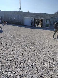
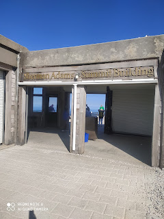
Spine chilling winds blow at the summit. I had to search for something to cover my body. Luckily.we had carried an extra ladies shawl that I used to cover my body. There is a restaurant , a Wether Observatory, Mount Washington Museum, a human and natural history museum , rest rooms and located on the summit , all in one complex . The complex has an elevator facility also. One can also learn about the mountain at the Observatory's Weather Discovery Center in North Conway town. Mark,our tour guide told us that Mount Washington summit is visited by over a quarter of a million people from all over the world each year. He also informed that during winters, the summit could have 20 feet snow and it is closed for tourists till the snow melts. The specially designed snow cars move over the surface of the snow and carry some adventurist to the mountain when the road is closed to regular tourists . I saw 25 feet tall poles fixed on road boundries which serve for identification of the route to the mountain after a heavy snow fall. Driven by 4 tracks rather than wheels, the Mount Washington Snow Coach transports guests to treeline on the Mount Washington Auto Road, at approximately 4,200 feet, into a sub-arctic world for a truly unforgettable adventure.
(Our tour guide Mark )
Mark , our tour guide told us this :-
" I am an immigrant from Canada. French speaking part." Vous parlez francais ? " ( Do you speak French ?) " un peu " ( A little ). Fine ,so I speak English. My father came from Canada and worked for laying that Ski slope that you see over there. Very hard life he faced here as immigrant. He built his house. My son studies in Washington. You folks from India. I know the Himalayas. The great mountain range . Very young still. You folks lucky. Today is a sunny day. Do you carry woolens ? It will be chilly up above.
We need to drive with care and caution.Steep uphill and downhill grades may put an extra strain on your vehicle's main components, from your engine to your brakes. You need to take certain precautions to help your vehicle, whether you're going up or down a mountain road.
Over more than150 years, there have been three fatalities on the Auto Road. In 1880, a stage overturned (in the hands of a drunk driver), and a passenger was killed. In 1984, a vehicle experienced brake failure about a mile up the road and was unable to make it down safely. So there are many spots to stop and cool your brakes. Hiking to the summit of Mount Washington is a tough challenge that requires a certain level of physical conditioning. Much of the route involves hopping from rock to rock or quad-busting giant steps or hand-over-hand crawling up lichen-covered boulders. You see those rock piles. These serve as both guideposts for hikers (the pointer stone points the way) and aesthetically appealing objects. Call them cairns, piled up rocks, or stone johnnies.
This bad and windy weather over here happens primarily for three reasons, the summit's prominence, its exposure and its storm tracks. At 6,288 feet, the summit is the highest point in the northeast. Normally, wind is slowed by friction from the ground."
( Avtar Mota )
PS
This trip was planned and executed by Sandeep and Impa for us.
 CHINAR SHADE
 by
Autarmota is licensed under a
Creative Commons Attribution-Noncommercial-No Derivative Works 2.5 India License.
Based on a work at
http:\\autarmota.blogspot.com\.


.jpg)


.jpeg)


No comments:
Post a Comment
Note: Only a member of this blog may post a comment.